


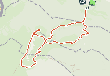
Saint-Cergue Randonnée

daniellebou
User

Length
13.9 km

Max alt
1671 m

Uphill gradient
704 m
Km-Effort
23 km

Min alt
1169 m

Downhill gradient
705 m
Boucle
Yes
Creation date :
2023-09-01 21:59:36.773
Updated on :
2023-09-01 22:08:10.654
5h17
Difficulty : Very difficult

FREE GPS app for hiking
 SityTrail
IGN / Geographical institutes
SityTrail Plus
The world is yours!
About
Trail Walking of 13.9 km to be discovered at Vaud, District de Nyon, Saint-Cergue. This trail is proposed by daniellebou.
Positioning
Country:
Switzerland
Region :
Vaud
Department/Province :
District de Nyon
Municipality :
Saint-Cergue
Location:
Unknown
Start:(Dec)
Start:(UTM)
279895 ; 5147214 (32T) N.
Comments