


Étang du Garbet

lebarça
User
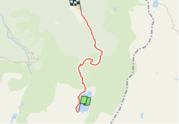

Length
4.8 km

Max alt
1721 m

Uphill gradient
32 m
Km-Effort
7.1 km

Min alt
1141 m

Downhill gradient
579 m
Boucle
No
Creation date :
2023-09-02 11:44:55.0
Updated on :
2023-09-02 15:26:48.15
3h04
Difficulty : Medium

FREE GPS app for hiking
 SityTrail
IGN / Geographical institutes
SityTrail Plus
The world is yours!
About
Trail Walking of 4.8 km to be discovered at Occitania, Ariège, Aulus-les-Bains. This trail is proposed by lebarça.
Positioning
Country:
France
Region :
Occitania
Department/Province :
Ariège
Municipality :
Aulus-les-Bains
Location:
Unknown
Start:(Dec)
Start:(UTM)
367397 ; 4734175 (31T) N.
Comments