


Auberives en Royan

meillon
User
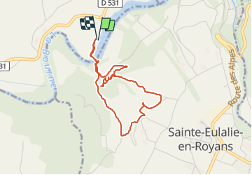

Length
4 km

Max alt
288 m

Uphill gradient
135 m
Km-Effort
5.8 km

Min alt
193 m

Downhill gradient
136 m
Boucle
Yes
Creation date :
2023-09-03 13:03:35.219
Updated on :
2023-09-03 14:34:44.608
1h30
Difficulty : Easy

FREE GPS app for hiking
 SityTrail
IGN / Geographical institutes
SityTrail Plus
The world is yours!
About
Trail Walking of 4 km to be discovered at Auvergne-Rhône-Alpes, Isère, Auberives-en-Royans. This trail is proposed by meillon.
Description
la passerelle sur la Bourne
Positioning
Country:
France
Region :
Auvergne-Rhône-Alpes
Department/Province :
Isère
Municipality :
Auberives-en-Royans
Location:
Unknown
Start:(Dec)
Start:(UTM)
683136 ; 4991899 (31T) N.
Comments