


variante

tiene
User
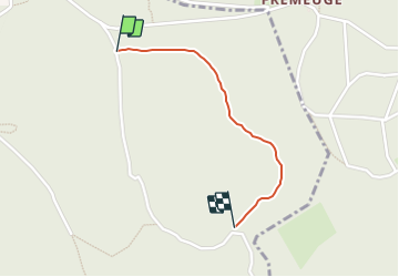

Length
920 m

Max alt
494 m

Uphill gradient
66 m
Km-Effort
1.6 km

Min alt
425 m

Downhill gradient
0 m
Boucle
No
Creation date :
2023-09-03 14:28:37.037
Updated on :
2023-09-03 14:35:13.726
6m
Difficulty : Easy

FREE GPS app for hiking
 SityTrail
IGN / Geographical institutes
SityTrail Plus
The world is yours!
About
Trail Walking of 920 m to be discovered at Bourgogne-Franche-Comté, Doubs, Mandeure. This trail is proposed by tiene.
Positioning
Country:
France
Region :
Bourgogne-Franche-Comté
Department/Province :
Doubs
Municipality :
Mandeure
Location:
Unknown
Start:(Dec)
Start:(UTM)
336361 ; 5255177 (32T) N.
Comments