


Pont du Gard

ymobernard
User
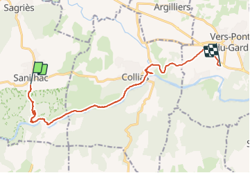

Length
13.8 km

Max alt
172 m

Uphill gradient
185 m
Km-Effort
16.6 km

Min alt
29 m

Downhill gradient
278 m
Boucle
No
Creation date :
2023-09-04 06:27:14.68
Updated on :
2023-09-04 12:43:27.749
3h30
Difficulty : Difficult

FREE GPS app for hiking
 SityTrail
IGN / Geographical institutes
SityTrail Plus
The world is yours!
About
Trail Walking of 13.8 km to be discovered at Occitania, Gard, Sanilhac-Sagriès. This trail is proposed by ymobernard.
Positioning
Country:
France
Region :
Occitania
Department/Province :
Gard
Municipality :
Sanilhac-Sagriès
Location:
Unknown
Start:(Dec)
Start:(UTM)
614384 ; 4867519 (31T) N.
Comments