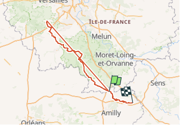
Trail  Nargis -  - Photo
© OpenStreetMap contributors
Length
Length
211 km
Max alt
Max alt
176 m
Uphill gradient
Uphill gradient
2558 m
Km-Effort
Km-Effort  
245 km
Min alt
Min alt
52 m
Downhill gradient
Downhill gradient
2514 m
Boucle
Boucle
No
Creation date :
2023-09-05 06:52:02.907
Updated on :
2023-09-05 06:52:02.907

(0 Reviews)


Scan this QR Code to open this trail in the SityTrail application

FREE GPS app for hiking

Logo SityTrail SityTrail

IGN / Geographical institutes

Download SityTrail from the App Store Download SityTrail from Google Play

Logo SityTrail SityTrail Plus

The world is yours!

Download SityTrail from the App Store Download SityTrail from Google Play Download SityTrail on Huawei AppGallery

About

Trail of 211 km to be discovered at Centre-Loire Valley, Loiret, Nargis. This trail is proposed by olivieraron.

Elevation profile

Points of interest

Point of interest Saint-Hilaire-les-Andrésis - End - Photo
olivieraron
SAINT-HILAIRE-LES-ANDRÉSIS 
Point of interest Limours - Start - Photo
olivieraron
LIMOURS 
Point of interest Saint-Hilaire-les-Andrésis - End - Photo
olivieraron
SAINT-HILAIRE-LES-ANDRÉSIS 
Point of interest Nargis - Start - Photo
olivieraron
NARGIS 

Positioning

Country:
France
Region :
Centre-Loire Valley
Department/Province :
Loiret
Municipality :
Nargis
Location:
Unknown
Start:(UTM)
481282 ; 5331072 (31U) N.


Close
My subscriptions