


Cordes

pb07
User
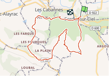

Length
12.1 km

Max alt
301 m

Uphill gradient
433 m
Km-Effort
17.7 km

Min alt
171 m

Downhill gradient
378 m
Boucle
No
Creation date :
2023-09-06 07:55:00.333
Updated on :
2023-09-06 12:39:36.337
4h04
Difficulty : Difficult

FREE GPS app for hiking
 SityTrail
IGN / Geographical institutes
SityTrail Plus
The world is yours!
About
Trail Walking of 12.1 km to be discovered at Occitania, Tarn, Cordes-sur-Ciel. This trail is proposed by pb07.
Positioning
Country:
France
Region :
Occitania
Department/Province :
Tarn
Municipality :
Cordes-sur-Ciel
Location:
Unknown
Start:(Dec)
Start:(UTM)
416581 ; 4879481 (31T) N.
Comments