


Mont-Dore ,grande cascade, Puy de l'Angle, Barbier, Monne, Tache,cascades Rossignolet et Queureuilh

marianne guichoux
User
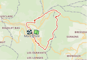

Length
16.7 km

Max alt
1727 m

Uphill gradient
909 m
Km-Effort
29 km

Min alt
997 m

Downhill gradient
914 m
Boucle
Yes
Creation date :
2023-09-07 09:48:38.075
Updated on :
2023-09-07 09:50:52.307
6h32
Difficulty : Very difficult

FREE GPS app for hiking
 SityTrail
IGN / Geographical institutes
SityTrail Plus
The world is yours!
About
Trail Walking of 16.7 km to be discovered at Auvergne-Rhône-Alpes, Puy-de-Dôme, Mont-Dore. This trail is proposed by marianne guichoux.
Positioning
Country:
France
Region :
Auvergne-Rhône-Alpes
Department/Province :
Puy-de-Dôme
Municipality :
Mont-Dore
Location:
Unknown
Start:(Dec)
Start:(UTM)
485271 ; 5046658 (31T) N.
Comments