


Mont Albert

aldaus
User
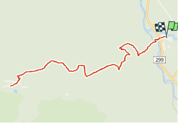

Length
13.5 km

Max alt
1061 m

Uphill gradient
880 m
Km-Effort
25 km

Min alt
207 m

Downhill gradient
879 m
Boucle
Yes
Creation date :
2023-09-08 10:47:08.352
Updated on :
2023-09-08 20:46:46.442
3h43
Difficulty : Medium

FREE GPS app for hiking
 SityTrail
IGN / Geographical institutes
SityTrail Plus
The world is yours!
About
Trail Walking of 13.5 km to be discovered at Quebec, La Haute-Gaspésie, Mont-Albert. This trail is proposed by aldaus.
Description
pour nous alpin...c est une rando sympa en moyenne montagne mais nous sommes au Québec à 1000 m alors tout change
Positioning
Country:
Canada
Region :
Quebec
Department/Province :
La Haute-Gaspésie
Municipality :
Mont-Albert
Location:
Unknown
Start:(Dec)
Start:(UTM)
710764 ; 5425555 (19U) N.
Comments