


26 Omblèze Druise col d'Ayes les Arbots moulin de la truite

HAL26
User
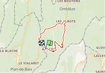

Length
12.9 km

Max alt
1033 m

Uphill gradient
631 m
Km-Effort
21 km

Min alt
565 m

Downhill gradient
636 m
Boucle
Yes
Creation date :
2023-09-09 06:35:23.691
Updated on :
2023-09-09 10:20:04.192
3h44
Difficulty : Easy

FREE GPS app for hiking
 SityTrail
IGN / Geographical institutes
SityTrail Plus
The world is yours!
About
Trail Walking of 12.9 km to be discovered at Auvergne-Rhône-Alpes, Drôme, Omblèze. This trail is proposed by HAL26.
Positioning
Country:
France
Region :
Auvergne-Rhône-Alpes
Department/Province :
Drôme
Municipality :
Omblèze
Location:
Unknown
Start:(Dec)
Start:(UTM)
673507 ; 4966288 (31T) N.
Comments