


Quad / moto

ikusen26@gmail.com
User

Length
71 km

Max alt
892 m

Uphill gradient
2462 m
Km-Effort
104 km

Min alt
232 m

Downhill gradient
2462 m
Boucle
Yes
Creation date :
2023-09-09 06:29:34.0
Updated on :
2023-09-09 12:35:27.558

FREE GPS app for hiking
 SityTrail
IGN / Geographical institutes
SityTrail Plus
The world is yours!
About
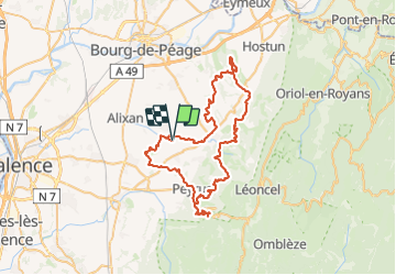
Trail of 71 km to be discovered at Auvergne-Rhône-Alpes, Drôme, Charpey. This trail is proposed by ikusen26@gmail.com.
Positioning
Country:
France
Region :
Auvergne-Rhône-Alpes
Department/Province :
Drôme
Municipality :
Charpey
Location:
Unknown
Start:(Dec)
Start:(UTM)
664568 ; 4980029 (31T) N.
Comments