


Argenteuil - Fort de Cormeilles

32mike32
User
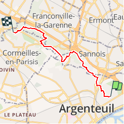

Length
9.2 km

Max alt
175 m

Uphill gradient
295 m
Km-Effort
12.8 km

Min alt
52 m

Downhill gradient
186 m
Boucle
No
Creation date :
2015-01-25 00:00:00.0
Updated on :
2015-01-25 00:00:00.0
44m
Difficulty : Unknown

FREE GPS app for hiking
 SityTrail
IGN / Geographical institutes
SityTrail Plus
The world is yours!
About
Trail Cycle of 9.2 km to be discovered at Ile-de-France, Val-d'Oise, Argenteuil. This trail is proposed by 32mike32.
Positioning
Country:
France
Region :
Ile-de-France
Department/Province :
Val-d'Oise
Municipality :
Argenteuil
Location:
Unknown
Start:(Dec)
Start:(UTM)
446213 ; 5422534 (31U) N.
Comments
