


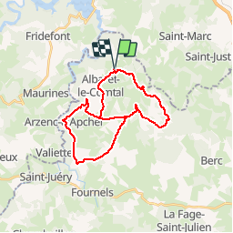
ALBARET 28 km VTT Courbepeyre Variante

benoit48
User

Length
28 km

Max alt
1093 m

Uphill gradient
547 m
Km-Effort
36 km

Min alt
951 m

Downhill gradient
548 m
Boucle
Yes
Creation date :
2018-01-06 00:00:00.0
Updated on :
2018-01-06 00:00:00.0
2h19
Difficulty : Medium

FREE GPS app for hiking
 SityTrail
IGN / Geographical institutes
SityTrail Plus
The world is yours!
About
Trail Mountain bike of 28 km to be discovered at Occitania, Lozère, Albaret-le-Comtal. This trail is proposed by benoit48.
Description
Albaret > Volpière > Courbepeyre > Arzenc > Le Villaret > Montaigut > La Pagésie > Azidiol > Le Crouzet > Albaret
Positioning
Country:
France
Region :
Occitania
Department/Province :
Lozère
Municipality :
Albaret-le-Comtal
Location:
Unknown
Start:(Dec)
Start:(UTM)
510905 ; 4969997 (31T) N.
Comments