


Étang de la Motte

michauxpaul
User
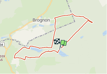

Length
9.1 km

Max alt
330 m

Uphill gradient
138 m
Km-Effort
10.9 km

Min alt
280 m

Downhill gradient
123 m
Boucle
Yes
Creation date :
2023-09-10 14:34:09.0
Updated on :
2023-09-10 17:43:07.029
2h35
Difficulty : Medium

FREE GPS app for hiking
 SityTrail
IGN / Geographical institutes
SityTrail Plus
The world is yours!
About
Trail Walking of 9.1 km to be discovered at Grand Est, Ardennes, Signy-le-Petit. This trail is proposed by michauxpaul.
Description
Trek
Photos


Positioning
Country:
France
Region :
Grand Est
Department/Province :
Ardennes
Municipality :
Signy-le-Petit
Location:
Unknown
Start:(Dec)
Start:(UTM)
593171 ; 5530312 (31U) N.
Comments