


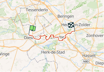
Diest naar viversel GR5

Ronalddef
User

Length
29 km

Max alt
72 m

Uphill gradient
259 m
Km-Effort
33 km

Min alt
16 m

Downhill gradient
246 m
Boucle
No
Creation date :
2023-09-12 05:39:16.634
Updated on :
2023-09-12 13:06:55.21
5h21
Difficulty : Very difficult

FREE GPS app for hiking
 SityTrail
IGN / Geographical institutes
SityTrail Plus
The world is yours!
About
Trail Walking of 29 km to be discovered at Flanders, Flemish Brabant, Diest. This trail is proposed by Ronalddef.
Positioning
Country:
Belgium
Region :
Flanders
Department/Province :
Flemish Brabant
Municipality :
Diest
Location:
Diest
Start:(Dec)
Start:(UTM)
643925 ; 5651096 (31U) N.
Comments