Trail Walking Trois-Rivières - Les trois -Rivières  - Photo
 José800
José800

User

© OpenStreetMap contributors
Length
Length
12 km
Max alt
Max alt
116 m
Uphill gradient
Uphill gradient
138 m
Km-Effort
Km-Effort  
13.9 km
Min alt
Min alt
43 m
Downhill gradient
Downhill gradient
137 m
Boucle
Boucle
Yes
Creation date :
2023-09-12 15:24:00.443
Updated on :
2023-09-12 15:35:28.606

(0 Reviews)

Walking
Walking
3h09
Difficulty : Difficult

Scan this QR Code to open this trail in the SityTrail application

FREE GPS app for hiking

Logo SityTrail SityTrail

IGN / Geographical institutes

Download SityTrail from the App Store Download SityTrail from Google Play

Logo SityTrail SityTrail World

The world is yours!

Download SityTrail from the App Store Download SityTrail from Google Play Download SityTrail on Huawei AppGallery

About

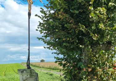
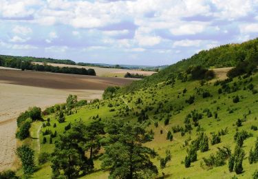
Trail Walking of 12 km to be discovered at Hauts-de-France, Somme, Trois-Rivières. This trail is proposed by José800.

Description

Trés belle randonnée à travers champs ,les marais , les forets  ,les villages et un joli panorama . Pierrepont-sur-Avre une jolie ville ;

Elevation profile

Positioning

Country:
France
Region :
Hauts-de-France
Department/Province :
Somme
Municipality :
Trois-Rivières
Location:
Unknown
Start:(UTM)
466730 ; 5507195 (31U) N.

Trails nearby

Trail Walking Davenescourt - circuit le Brûle modifié  - Photo
Walking
José800

Walking

Medium
Davenescourt, Hauts-de-France, Somme, France
10.4 km | 11.9 km-effort
2h 28min
Yes
Trail Walking Fignières - La montagne de Fignière - Photo
Walking
tracegps

Walking

Medium
(1)
Fignières, Hauts-de-France, Somme, France
3.4 km | 4.1 km-effort
1h 0min
Yes
Trail Walking Davenescourt - Davenescourt  80 Le Brule - Photo
Walking
José800

Walking

Difficult
Davenescourt, Hauts-de-France, Somme, France
13.1 km | 15.1 km-effort
3h 25min
Yes
Trail Other activity Trois-Rivières - Comptoir Hamel - Photo
Other activity
jema.bernard

Other activity

Very easy
Trois-Rivières, Hauts-de-France, Somme, France
13.4 km | 15.5 km-effort
2h 51min
No
Trail Other activity Braches - braches - Photo
Other activity
jema.bernard

Other activity

Easy
Braches, Hauts-de-France, Somme, France
13.4 km | 15.5 km-effort
3h 4min
No
Trail Walking Davenescourt - davenucours - Photo
Walking
lefrancm

Walking

Very easy
Davenescourt, Hauts-de-France, Somme, France
16.5 km | 19.5 km-effort
3h 34min
Yes
Trail Walking Trois-Rivières - Contoire Hamel - Photo
Walking
jpblimond

Walking

Easy
Trois-Rivières, Hauts-de-France, Somme, France
12.2 km | 14 km-effort
3h 18min
Yes
Trail Quad Grivesnes - Sommes  - Photo
Quad
Erpop1974

Quad

Grivesnes, Hauts-de-France, Somme, France
41 km | 48 km-effort
1h 14min
No
Trail Other activity Fignières - Fignières-Larris-Boussicourt-Fignières - Photo
Other activity
rarnaud

Other activity

Very easy
Fignières, Hauts-de-France, Somme, France
6.3 km | 7.5 km-effort
1h 46min
Yes


Close
My subscriptions