


2023 09 - Lasso refuge de Merdençon

Chabard
User
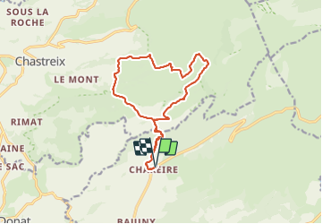

Length
15.1 km

Max alt
1363 m

Uphill gradient
398 m
Km-Effort
20 km

Min alt
1163 m

Downhill gradient
398 m
Boucle
Yes
Creation date :
2023-09-13 07:11:11.0
Updated on :
2023-09-13 16:20:09.131
4h37
Difficulty : Very difficult

FREE GPS app for hiking
 SityTrail
IGN / Geographical institutes
SityTrail Plus
The world is yours!
About
Trail Walking of 15.1 km to be discovered at Auvergne-Rhône-Alpes, Puy-de-Dôme, Picherande. This trail is proposed by Chabard.
Description
Lasso refuge de Merdençon
Positioning
Country:
France
Region :
Auvergne-Rhône-Alpes
Department/Province :
Puy-de-Dôme
Municipality :
Picherande
Location:
Unknown
Start:(Dec)
Start:(UTM)
482715 ; 5036718 (31T) N.
Comments