


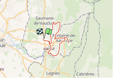
Balade autour de Fontaine de Vaucluse

kephas
User

Length
13.2 km

Max alt
318 m

Uphill gradient
449 m
Km-Effort
19.2 km

Min alt
73 m

Downhill gradient
449 m
Boucle
Yes
Creation date :
2023-09-13 16:55:40.24
Updated on :
2023-09-13 16:59:58.617
4h22
Difficulty : Very difficult

FREE GPS app for hiking
 SityTrail
IGN / Geographical institutes
SityTrail Plus
The world is yours!
About
Trail Walking of 13.2 km to be discovered at Provence-Alpes-Côte d'Azur, Vaucluse, Saumane-de-Vaucluse. This trail is proposed by kephas.
Description
Boucle sans difficulté
Positioning
Country:
France
Region :
Provence-Alpes-Côte d'Azur
Department/Province :
Vaucluse
Municipality :
Saumane-de-Vaucluse
Location:
Unknown
Start:(Dec)
Start:(UTM)
669029 ; 4865317 (31T) N.
Comments