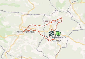
saint antonin vers entrecasteaux club

clintest
User

Length
17 km

Max alt
334 m

Uphill gradient
521 m
Km-Effort
24 km

Min alt
148 m

Downhill gradient
521 m
Boucle
Yes
Creation date :
2023-09-14 06:09:41.544
Updated on :
2023-09-14 06:10:18.975
5h27
Difficulty : Medium

FREE GPS app for hiking
 SityTrail
IGN / Geographical institutes
SityTrail Plus
The world is yours!
About
Trail On foot of 17 km to be discovered at Provence-Alpes-Côte d'Azur, Var, Saint-Antonin-du-Var. This trail is proposed by clintest.
Positioning
Country:
France
Region :
Provence-Alpes-Côte d'Azur
Department/Province :
Var
Municipality :
Saint-Antonin-du-Var
Location:
Unknown
Start:(Dec)
Start:(UTM)
280721 ; 4820674 (32T) N.
Comments