


new

olivieraron
User
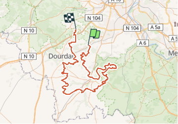

Length
151 km

Max alt
164 m

Uphill gradient
1885 m
Km-Effort
176 km

Min alt
56 m

Downhill gradient
1863 m
Boucle
No
Creation date :
2023-09-14 06:42:54.991
Updated on :
2023-09-14 08:50:03.613
0m
Difficulty : Very easy

FREE GPS app for hiking
 SityTrail
IGN / Geographical institutes
SityTrail Plus
The world is yours!
About
Trail Moto cross of 151 km to be discovered at Ile-de-France, Essonne, Breuillet. This trail is proposed by olivieraron.
Positioning
Country:
France
Region :
Ile-de-France
Department/Province :
Essonne
Municipality :
Breuillet
Location:
Unknown
Start:(Dec)
Start:(UTM)
438242 ; 5379869 (31U) N.
Comments