


odet

macrid
User
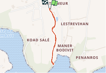

Length
1.4 km

Max alt
30 m

Uphill gradient
18 m
Km-Effort
1.7 km

Min alt
4 m

Downhill gradient
18 m
Boucle
Yes
Creation date :
2023-06-24 11:21:13.469
Updated on :
2023-09-14 11:30:31.196
39m
Difficulty : Very easy

FREE GPS app for hiking
 SityTrail
IGN / Geographical institutes
SityTrail Plus
The world is yours!
About
Trail Walking of 1.4 km to be discovered at Brittany, Finistère, Plomelin. This trail is proposed by macrid.
Positioning
Country:
France
Region :
Brittany
Department/Province :
Finistère
Municipality :
Plomelin
Location:
Unknown
Start:(Dec)
Start:(UTM)
413001 ; 5306064 (30T) N.
Comments