


Louannec - GR34 PR - 11.5km 185m 3h00 (40mn) - 2023 09 14

Orcal37
User GUIDE
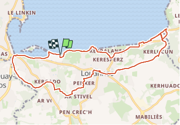

Length
11.5 km

Max alt
72 m

Uphill gradient
184 m
Km-Effort
13.9 km

Min alt
0 m

Downhill gradient
184 m
Boucle
Yes
Creation date :
2023-09-14 08:30:09.42
Updated on :
2023-09-23 14:19:14.708
3h00
Difficulty : Difficult

FREE GPS app for hiking
 SityTrail
IGN / Geographical institutes
SityTrail Plus
The world is yours!
About
Trail Walking of 11.5 km to be discovered at Brittany, Côtes-d'Armor, Louannec. This trail is proposed by Orcal37.
Description
Louannec - GR34 - Pont ar Sauz - PR - Nantouar - Feu Aval - 11.5km 185m 3h00 (40mn) - 2023 09 14
Photos
 - 2023 09 14 - Photo 1")
 - 2023 09 14 - Photo 2")
 - 2023 09 14 - Photo 3")
 - 2023 09 14 - Photo 4")
 - 2023 09 14 - Photo 5")
 - 2023 09 14 - Photo 6")
 - 2023 09 14 - Photo 7")
 - 2023 09 14 - Photo 8")
 - 2023 09 14 - Photo 9")
 - 2023 09 14 - Photo 10")
Positioning
Country:
France
Region :
Brittany
Department/Province :
Côtes-d'Armor
Municipality :
Louannec
Location:
Unknown
Start:(Dec)
Start:(UTM)
468827 ; 5405096 (30U) N.
Comments