


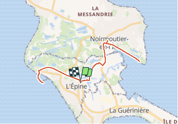
L’Epine - Noimoutier - Port Morin

Pat_83200
User

Length
18.6 km

Max alt
6 m

Uphill gradient
56 m
Km-Effort
19.4 km

Min alt
-3 m

Downhill gradient
55 m
Boucle
Yes
Creation date :
2023-09-15 06:32:34.0
Updated on :
2023-09-15 09:26:12.472
2h53
Difficulty : Very easy

FREE GPS app for hiking
 SityTrail
IGN / Geographical institutes
SityTrail Plus
The world is yours!
About
Trail Mountain bike of 18.6 km to be discovered at Pays de la Loire, Vendée, L'Épine. This trail is proposed by Pat_83200.
Description
Piste cyclable
Positioning
Country:
France
Region :
Pays de la Loire
Department/Province :
Vendée
Municipality :
L'Épine
Location:
Unknown
Start:(Dec)
Start:(UTM)
555966 ; 5203314 (30T) N.
Comments