


Le Capucin-Puy de Cliergue-Val de Courre-2023-09-16

Nordic33
User GUIDE
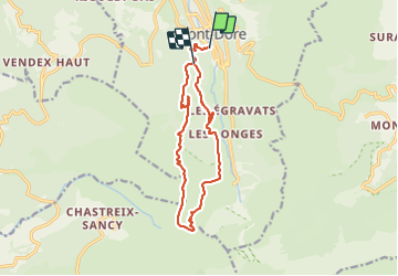

Length
13.6 km

Max alt
1727 m

Uphill gradient
835 m
Km-Effort
24 km

Min alt
1053 m

Downhill gradient
649 m
Boucle
No
Creation date :
2023-09-16 06:44:56.601
Updated on :
2023-09-18 12:56:52.749
5h29
Difficulty : Very difficult

FREE GPS app for hiking
 SityTrail
IGN / Geographical institutes
SityTrail Plus
The world is yours!
About
Trail Walking of 13.6 km to be discovered at Auvergne-Rhône-Alpes, Puy-de-Dôme, Mont-Dore. This trail is proposed by Nordic33.
Positioning
Country:
France
Region :
Auvergne-Rhône-Alpes
Department/Province :
Puy-de-Dôme
Municipality :
Mont-Dore
Location:
Unknown
Start:(Dec)
Start:(UTM)
485122 ; 5046507 (31T) N.
Comments