


Etretat - Fécamp

Jamyfredo
User
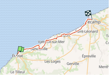

Length
17.7 km

Max alt
98 m

Uphill gradient
370 m
Km-Effort
23 km

Min alt
2 m

Downhill gradient
375 m
Boucle
No
Creation date :
2023-09-16 20:08:21.0
Updated on :
2023-09-18 15:45:48.547
4h20
Difficulty : Medium

FREE GPS app for hiking
 SityTrail
IGN / Geographical institutes
SityTrail Plus
The world is yours!
About
Trail Walking of 17.7 km to be discovered at Normandy, Seine-Maritime, Étretat. This trail is proposed by Jamyfredo.
Positioning
Country:
France
Region :
Normandy
Department/Province :
Seine-Maritime
Municipality :
Étretat
Location:
Unknown
Start:(Dec)
Start:(UTM)
298247 ; 5509821 (31U) N.
Comments