


cascade de queureuil-2023-09-17

Nordic33
User GUIDE

Length
6.6 km

Max alt
1113 m

Uphill gradient
271 m
Km-Effort
10.2 km

Min alt
997 m

Downhill gradient
265 m
Boucle
Yes
Creation date :
2023-09-17 06:38:35.852
Updated on :
2023-09-18 12:51:18.015
2h17
Difficulty : Medium

FREE GPS app for hiking
 SityTrail
IGN / Geographical institutes
SityTrail Plus
The world is yours!
About
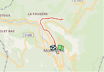
Trail Walking of 6.6 km to be discovered at Auvergne-Rhône-Alpes, Puy-de-Dôme, Mont-Dore. This trail is proposed by Nordic33.
Positioning
Country:
France
Region :
Auvergne-Rhône-Alpes
Department/Province :
Puy-de-Dôme
Municipality :
Mont-Dore
Location:
Unknown
Start:(Dec)
Start:(UTM)
485267 ; 5046675 (31T) N.
Comments