


2023 09 - Le Suet

Chabard
User
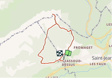

Length
7.4 km

Max alt
1799 m

Uphill gradient
788 m
Km-Effort
17.9 km

Min alt
1001 m

Downhill gradient
789 m
Boucle
Yes
Creation date :
2023-09-17 06:20:42.0
Updated on :
2023-09-17 09:21:17.116
3h00
Difficulty : Difficult

FREE GPS app for hiking
 SityTrail
IGN / Geographical institutes
SityTrail Plus
The world is yours!
About
Trail Walking of 7.4 km to be discovered at Auvergne-Rhône-Alpes, Upper Savoy, Saint-Jean-de-Sixt. This trail is proposed by Chabard.
Description
Le Suet
Positioning
Country:
France
Region :
Auvergne-Rhône-Alpes
Department/Province :
Upper Savoy
Municipality :
Saint-Jean-de-Sixt
Location:
Unknown
Start:(Dec)
Start:(UTM)
297448 ; 5088816 (32T) N.
Comments