


bolena plus baume

dcharbonnier
User

Length
14.9 km

Max alt
1020 m

Uphill gradient
469 m
Km-Effort
21 km

Min alt
654 m

Downhill gradient
474 m
Boucle
Yes
Creation date :
2023-09-17 07:26:22.663
Updated on :
2023-09-17 12:36:33.399
5h08
Difficulty : Difficult

FREE GPS app for hiking
 SityTrail
IGN / Geographical institutes
SityTrail Plus
The world is yours!
About
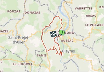
Trail Walking of 14.9 km to be discovered at Auvergne-Rhône-Alpes, Haute-Loire, Alleyras. This trail is proposed by dcharbonnier.
Photos

Positioning
Country:
France
Region :
Auvergne-Rhône-Alpes
Department/Province :
Haute-Loire
Municipality :
Alleyras
Location:
Unknown
Start:(Dec)
Start:(UTM)
552826 ; 4973852 (31T) N.
Comments