


villard les Blamont

danif
User
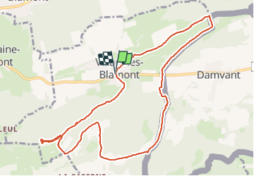

Length
11.3 km

Max alt
814 m

Uphill gradient
373 m
Km-Effort
16.2 km

Min alt
598 m

Downhill gradient
371 m
Boucle
Yes
Creation date :
2023-09-14 12:21:15.737
Updated on :
2023-09-18 19:30:13.38
3h23
Difficulty : Very easy

FREE GPS app for hiking
 SityTrail
IGN / Geographical institutes
SityTrail Plus
The world is yours!
About
Trail Nordic walking of 11.3 km to be discovered at Bourgogne-Franche-Comté, Doubs, Villars-lès-Blamont. This trail is proposed by danif.
Positioning
Country:
France
Region :
Bourgogne-Franche-Comté
Department/Province :
Doubs
Municipality :
Villars-lès-Blamont
Location:
Unknown
Start:(Dec)
Start:(UTM)
339358 ; 5248734 (32T) N.
Comments