


les gorges saint Pierre

taguette
User
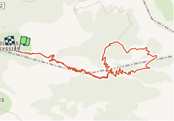

Length
15.8 km

Max alt
1939 m

Uphill gradient
894 m
Km-Effort
28 km

Min alt
1275 m

Downhill gradient
900 m
Boucle
Yes
Creation date :
2023-09-19 07:38:24.364
Updated on :
2023-09-19 12:16:00.996
4h34
Difficulty : Very difficult

FREE GPS app for hiking
 SityTrail
IGN / Geographical institutes
SityTrail Plus
The world is yours!
About
Trail Walking of 15.8 km to be discovered at Provence-Alpes-Côte d'Azur, Alpes-de-Haute-Provence, Beauvezer. This trail is proposed by taguette.
Positioning
Country:
France
Region :
Provence-Alpes-Côte d'Azur
Department/Province :
Alpes-de-Haute-Provence
Municipality :
Beauvezer
Location:
Unknown
Start:(Dec)
Start:(UTM)
308256 ; 4888758 (32T) N.
Comments