


SOURRIBES . LE CREPON . O M

RobinMicheline
User GUIDE
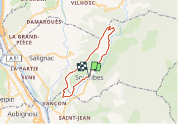

Length
12 km

Max alt
810 m

Uphill gradient
427 m
Km-Effort
17.7 km

Min alt
469 m

Downhill gradient
423 m
Boucle
Yes
Creation date :
2023-09-19 06:12:34.454
Updated on :
2023-09-19 15:50:36.0
4h01
Difficulty : Difficult

FREE GPS app for hiking
 SityTrail
IGN / Geographical institutes
SityTrail Plus
The world is yours!
About
Trail Walking of 12 km to be discovered at Provence-Alpes-Côte d'Azur, Alpes-de-Haute-Provence, Sourribes. This trail is proposed by RobinMicheline.
Photos


Positioning
Country:
France
Region :
Provence-Alpes-Côte d'Azur
Department/Province :
Alpes-de-Haute-Provence
Municipality :
Sourribes
Location:
Unknown
Start:(Dec)
Start:(UTM)
261281 ; 4892619 (32T) N.
Comments