


20230919 ver les chartes

Jeanclaudebic
User
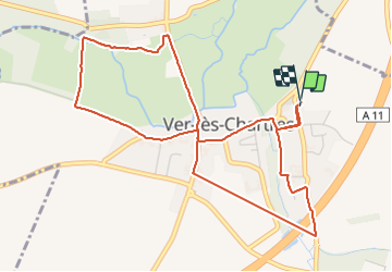

Length
5.4 km

Max alt
144 m

Uphill gradient
36 m
Km-Effort
5.8 km

Min alt
131 m

Downhill gradient
37 m
Boucle
Yes
Creation date :
2023-09-19 11:58:05.988
Updated on :
2023-09-19 13:34:09.088
1h18
Difficulty : Easy

FREE GPS app for hiking
 SityTrail
IGN / Geographical institutes
SityTrail Plus
The world is yours!
About
Trail Walking of 5.4 km to be discovered at Centre-Loire Valley, Eure-et-Loir, Ver-lès-Chartres. This trail is proposed by Jeanclaudebic.
Positioning
Country:
France
Region :
Centre-Loire Valley
Department/Province :
Eure-et-Loir
Municipality :
Ver-lès-Chartres
Location:
Unknown
Start:(Dec)
Start:(UTM)
387882 ; 5360383 (31U) N.
Comments