


2023 09 20 Fontainebleau

hal2012
User
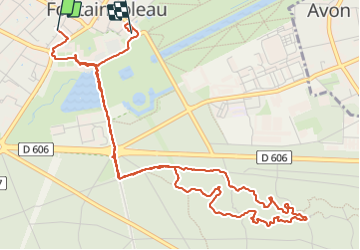

Length
6.8 km

Max alt
122 m

Uphill gradient
76 m
Km-Effort
7.8 km

Min alt
70 m

Downhill gradient
81 m
Boucle
No
Creation date :
2023-09-20 08:14:34.856
Updated on :
2023-09-20 11:00:43.479
2h05
Difficulty : Medium

FREE GPS app for hiking
 SityTrail
IGN / Geographical institutes
SityTrail Plus
The world is yours!
About
Trail Walking of 6.8 km to be discovered at Ile-de-France, Seine-et-Marne, Fontainebleau. This trail is proposed by hal2012.
Positioning
Country:
France
Region :
Ile-de-France
Department/Province :
Seine-et-Marne
Municipality :
Fontainebleau
Location:
Unknown
Start:(Dec)
Start:(UTM)
477605 ; 5361219 (31U) N.
Comments