


les monts latari

marchev
User
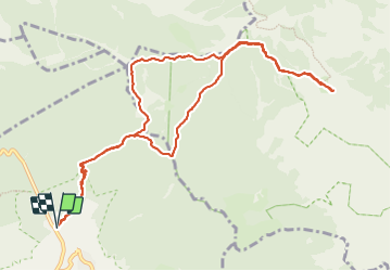

Length
13.1 km

Max alt
1061 m

Uphill gradient
481 m
Km-Effort
19.5 km

Min alt
712 m

Downhill gradient
478 m
Boucle
Yes
Creation date :
2023-09-19 07:16:45.817
Updated on :
2023-09-21 13:22:43.008
6h55
Difficulty : Medium

FREE GPS app for hiking
 SityTrail
IGN / Geographical institutes
SityTrail Plus
The world is yours!
About
Trail Walking of 13.1 km to be discovered at Campania, Napoli, Agerola. This trail is proposed by marchev.
Photos


Positioning
Country:
Italy
Region :
Campania
Department/Province :
Napoli
Municipality :
Agerola
Location:
Unknown
Start:(Dec)
Start:(UTM)
461456 ; 4499829 (33T) N.
Comments