


col de l'âne plein vue

taguette
User
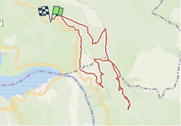

Length
13.1 km

Max alt
1244 m

Uphill gradient
845 m
Km-Effort
24 km

Min alt
654 m

Downhill gradient
844 m
Boucle
Yes
Creation date :
2023-09-22 07:26:42.041
Updated on :
2023-09-22 14:42:53.579
7h11
Difficulty : Very difficult

FREE GPS app for hiking
 SityTrail
IGN / Geographical institutes
SityTrail Plus
The world is yours!
About
Trail Walking of 13.1 km to be discovered at Provence-Alpes-Côte d'Azur, Alpes-de-Haute-Provence, Moustiers-Sainte-Marie. This trail is proposed by taguette.
Positioning
Country:
France
Region :
Provence-Alpes-Côte d'Azur
Department/Province :
Alpes-de-Haute-Provence
Municipality :
Moustiers-Sainte-Marie
Location:
Unknown
Start:(Dec)
Start:(UTM)
278506 ; 4854979 (32T) N.
Comments