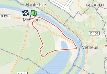
Promenade en bord de Seine dans la boucle de Moisson

les randos d'Olivier
partout a pied et en moto

Length
6.1 km

Max alt
39 m

Uphill gradient
53 m
Km-Effort
6.8 km

Min alt
12 m

Downhill gradient
53 m
Boucle
Yes
Creation date :
2023-09-23 13:07:42.273
Updated on :
2023-09-23 13:18:57.733
1h32
Difficulty : Medium

FREE GPS app for hiking
 SityTrail
IGN / Geographical institutes
SityTrail Plus
The world is yours!
About
Trail Walking of 6.1 km to be discovered at Ile-de-France, Yvelines, Moisson. This trail is proposed by les randos d'Olivier.
Points of interest


Positioning
Country:
France
Region :
Ile-de-France
Department/Province :
Yvelines
Municipality :
Moisson
Location:
Unknown
Start:(Dec)
Start:(UTM)
402703 ; 5436506 (31U) N.
Comments