


20230920 Sours

Jeanclaudebic
User
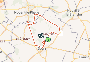

Length
13.6 km

Max alt
157 m

Uphill gradient
78 m
Km-Effort
14.6 km

Min alt
134 m

Downhill gradient
79 m
Boucle
No
Creation date :
2023-09-23 06:49:40.732
Updated on :
2023-09-27 07:49:26.973
2h25
Difficulty : Difficult

FREE GPS app for hiking
 SityTrail
IGN / Geographical institutes
SityTrail Plus
The world is yours!
About
Trail Walking of 13.6 km to be discovered at Centre-Loire Valley, Eure-et-Loir, Sours. This trail is proposed by Jeanclaudebic.
Positioning
Country:
France
Region :
Centre-Loire Valley
Department/Province :
Eure-et-Loir
Municipality :
Sours
Location:
Unknown
Start:(Dec)
Start:(UTM)
396442 ; 5363320 (31U) N.
Comments