


Au sud du Pic Saint Loup

kephas
User
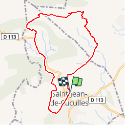

Length
9.2 km

Max alt
355 m

Uphill gradient
325 m
Km-Effort
13.6 km

Min alt
111 m

Downhill gradient
321 m
Boucle
Yes
Creation date :
2016-03-09 00:00:00.0
Updated on :
2016-03-09 00:00:00.0
2h54
Difficulty : Unknown

FREE GPS app for hiking
 SityTrail
IGN / Geographical institutes
SityTrail Plus
The world is yours!
About
Trail Walking of 9.2 km to be discovered at Occitania, Hérault, Saint-Jean-de-Cuculles. This trail is proposed by kephas.
Positioning
Country:
France
Region :
Occitania
Department/Province :
Hérault
Municipality :
Saint-Jean-de-Cuculles
Location:
Unknown
Start:(Dec)
Start:(UTM)
567260 ; 4844961 (31T) N.
Comments
difficile pour les + de 60ans très sportif comme parcour