


crête des Couniets et crête de la selle

orsel
User GUIDE
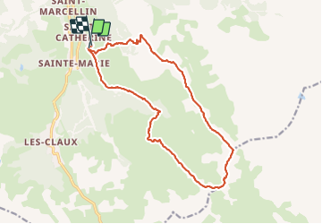

Length
17 km

Max alt
2806 m

Uphill gradient
1075 m
Km-Effort
31 km

Min alt
1849 m

Downhill gradient
1064 m
Boucle
Yes
Creation date :
2023-09-24 06:56:08.958
Updated on :
2023-09-24 20:44:38.33
6h46
Difficulty : Medium

FREE GPS app for hiking
 SityTrail
IGN / Geographical institutes
SityTrail Plus
The world is yours!
About
Trail Walking of 17 km to be discovered at Provence-Alpes-Côte d'Azur, Hautes-Alpes, Vars. This trail is proposed by orsel.
Positioning
Country:
France
Region :
Provence-Alpes-Côte d'Azur
Department/Province :
Hautes-Alpes
Municipality :
Vars
Location:
Unknown
Start:(Dec)
Start:(UTM)
317191 ; 4940919 (32T) N.
Comments