


Lac de Caillaouas

chasle
User
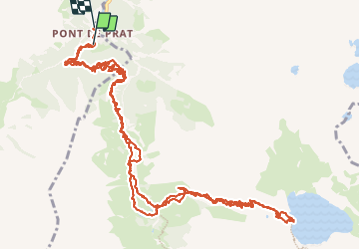

Length
20 km

Max alt
2194 m

Uphill gradient
1322 m
Km-Effort
38 km

Min alt
1234 m

Downhill gradient
1355 m
Boucle
No
Creation date :
2023-09-24 06:41:41.993
Updated on :
2023-09-25 07:19:21.374
7h58
Difficulty : Difficult

FREE GPS app for hiking
 SityTrail
IGN / Geographical institutes
SityTrail Plus
The world is yours!
About
Trail Walking of 20 km to be discovered at Occitania, Hautespyrenees, Génos. This trail is proposed by chasle.
Positioning
Country:
France
Region :
Occitania
Department/Province :
Hautespyrenees
Municipality :
Génos
Location:
Unknown
Start:(Dec)
Start:(UTM)
287944 ; 4735575 (31T) N.
Comments