


Le blavet

ninia
User
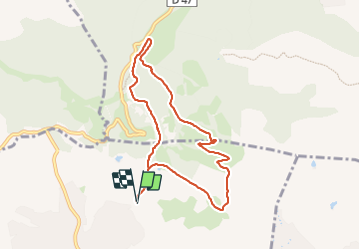

Length
8.4 km

Max alt
270 m

Uphill gradient
219 m
Km-Effort
11.3 km

Min alt
74 m

Downhill gradient
220 m
Boucle
Yes
Creation date :
2023-09-25 06:23:26.914
Updated on :
2023-09-25 09:27:39.62
3h03
Difficulty : Easy

FREE GPS app for hiking
 SityTrail
IGN / Geographical institutes
SityTrail Plus
The world is yours!
About
Trail Walking of 8.4 km to be discovered at Provence-Alpes-Côte d'Azur, Var, Roquebrune-sur-Argens. This trail is proposed by ninia.
Positioning
Country:
France
Region :
Provence-Alpes-Côte d'Azur
Department/Province :
Var
Municipality :
Roquebrune-sur-Argens
Location:
Unknown
Start:(Dec)
Start:(UTM)
310242 ; 4819859 (32T) N.
Comments