


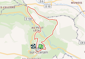
De l'anis au vignoble. Flavigny

Iahns
User

Length
8.5 km

Max alt
412 m

Uphill gradient
290 m
Km-Effort
12.4 km

Min alt
260 m

Downhill gradient
291 m
Boucle
Yes
Creation date :
2023-09-25 08:13:32.18
Updated on :
2023-09-25 11:25:34.905
3h11
Difficulty : Easy

FREE GPS app for hiking
 SityTrail
IGN / Geographical institutes
SityTrail Plus
The world is yours!
About
Trail Walking of 8.5 km to be discovered at Bourgogne-Franche-Comté, Côte-d'Or, Flavigny-sur-Ozerain. This trail is proposed by Iahns.
Positioning
Country:
France
Region :
Bourgogne-Franche-Comté
Department/Province :
Côte-d'Or
Municipality :
Flavigny-sur-Ozerain
Location:
Unknown
Start:(Dec)
Start:(UTM)
615186 ; 5263048 (31T) N.
Comments