Trail On foot Lourouer-Saint-Laurent - Circuit pédestre n°34

Circuit pédestre n°34 "légendes et mystères"

 fanthou
fanthou

User

© OpenStreetMap contributors
Length
Length
6.4 km
Max alt
Max alt
248 m
Uphill gradient
Uphill gradient
53 m
Km-Effort
Km-Effort  
7.1 km
Min alt
Min alt
201 m
Downhill gradient
Downhill gradient
53 m
Boucle
Boucle
Yes
Creation date :
2023-09-26 08:46:00.538
Updated on :
2023-09-26 08:46:43.686

(0 Reviews)

On foot
On foot
1h36
Difficulty : Easy

Scan this QR Code to open this trail in the SityTrail application

FREE GPS app for hiking

Logo SityTrail SityTrail

IGN / Geographical institutes

Download SityTrail from the App Store Download SityTrail from Google Play

Logo SityTrail SityTrail World

The world is yours!

Download SityTrail from the App Store Download SityTrail from Google Play Download SityTrail on Huawei AppGallery

About

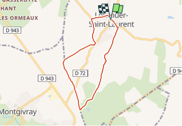
Trail On foot of 6.4 km to be discovered at Centre-Loire Valley, Indre, Lourouer-Saint-Laurent. This trail is proposed by fanthou.

Description

Ce circuit vous mènera au cœur des légendes du Berry à Lourouer-St-Laurent. Situé sur la plaine de Vic ce parcours de 6.5km ne présente aucune difficulté : terrain plat, horizon dégagé et peu de route !  Une idée de balade facile à tester pour une sortie en famille autour de Lourouer-St-Laurent Départ : devant l'école de Lourouer-St-Laurent située en face de la Mairie .

Elevation profile

Positioning

Country:
France
Region :
Centre-Loire Valley
Department/Province :
Indre
Municipality :
Lourouer-Saint-Laurent
Location:
Unknown
Start:(UTM)
424358 ; 5163804 (31T) N.

Trails nearby

Trail Walking La Berthenoux - Sur les pas des Maîtres Sonneurs (La Berthenoux - La Motte-Feuilly) - Photo
Walking
tracegps

Walking

Difficult
La Berthenoux, Centre-Loire Valley, Indre, France
19 km | 21 km-effort
4h 45min
No
Trail Walking La Châtre - Sur les pas des Maîtres Sonneurs (La Châtre - La Berthenoux) - Photo
Walking
tracegps

Walking

Difficult
La Châtre, Centre-Loire Valley, Indre, France
18.5 km | 21 km-effort
4h 40min
No
Trail Walking Saint-Chartier - Fôret de St Chartier - Photo
Walking
GUIDE
randotines

Walking

Easy
(1)
Saint-Chartier, Centre-Loire Valley, Indre, France
12.7 km | 15 km-effort
3h 17min
Yes
Trail Walking Thevet-Saint-Julien - Circuit pédestre n°42
Walking
fanthou

Walking

Medium
Thevet-Saint-Julien, Centre-Loire Valley, Indre, France
7.7 km | 8.9 km-effort
2h 1min
Yes
Trail On foot Montgivray - Circuit pédestre n°13
On foot
fanthou

On foot

Easy
Montgivray, Centre-Loire Valley, Indre, France
7.5 km | 8.5 km-effort
1h 55min
Yes
Trail On foot La Châtre - Sur les pas des Maîtres Sonneurs entre Berry et Bourbonnais - Photo
On foot
zefreefly

On foot

Very difficult
La Châtre, Centre-Loire Valley, Indre, France
191 km | 227 km-effort
51h 33min
Yes
Trail Walking Nohant-Vic - boucle noyant vic - Photo
Walking
fab0202

Walking

Easy
Nohant-Vic, Centre-Loire Valley, Indre, France
10.6 km | 12.1 km-effort
2h 20min
Yes
Trail Walking Nohant-Vic - Nohant - Photo
Walking
jlrayon

Walking

Easy
Nohant-Vic, Centre-Loire Valley, Indre, France
5.2 km | 5.9 km-effort
1h 20min
Yes
Trail Walking Thevet-Saint-Julien - Campagne berrichonne  : autour de Thévet Saint-Julien - Photo
Walking
tracegps

Walking

Medium
Thevet-Saint-Julien, Centre-Loire Valley, Indre, France
20 km | 23 km-effort
5h 0min
Yes


Close
My subscriptions