


Moutier sainte Marie camping

taguette
User
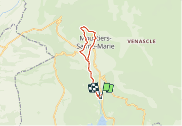

Length
10.6 km

Max alt
767 m

Uphill gradient
293 m
Km-Effort
14.5 km

Min alt
495 m

Downhill gradient
296 m
Boucle
Yes
Creation date :
2023-09-23 08:26:11.215
Updated on :
2023-09-26 11:49:47.036
2h32
Difficulty : Easy

FREE GPS app for hiking
 SityTrail
IGN / Geographical institutes
SityTrail Plus
The world is yours!
About
Trail Walking of 10.6 km to be discovered at Provence-Alpes-Côte d'Azur, Alpes-de-Haute-Provence, Moustiers-Sainte-Marie. This trail is proposed by taguette.
Positioning
Country:
France
Region :
Provence-Alpes-Côte d'Azur
Department/Province :
Alpes-de-Haute-Provence
Municipality :
Moustiers-Sainte-Marie
Location:
Unknown
Start:(Dec)
Start:(UTM)
276910 ; 4855403 (32T) N.
Comments