


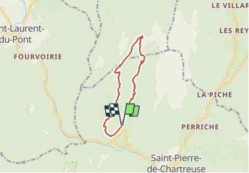
col de la Ruchere

saporito antoine
User

Length
11.9 km

Max alt
1433 m

Uphill gradient
646 m
Km-Effort
21 km

Min alt
834 m

Downhill gradient
644 m
Boucle
Yes
Creation date :
2023-07-16 09:00:36.607
Updated on :
2023-09-26 14:24:26.171
6h27
Difficulty : Medium

FREE GPS app for hiking
 SityTrail
IGN / Geographical institutes
SityTrail Plus
The world is yours!
About
Trail Walking of 11.9 km to be discovered at Auvergne-Rhône-Alpes, Isère, Saint-Pierre-de-Chartreuse. This trail is proposed by saporito antoine.
Positioning
Country:
France
Region :
Auvergne-Rhône-Alpes
Department/Province :
Isère
Municipality :
Saint-Pierre-de-Chartreuse
Location:
Unknown
Start:(Dec)
Start:(UTM)
718373 ; 5026211 (31T) N.
Comments