


Roumanie étape 1

MathieuBourgois
User
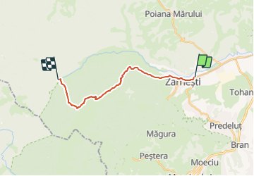

Length
15.7 km

Max alt
2113 m

Uphill gradient
1524 m
Km-Effort
36 km

Min alt
703 m

Downhill gradient
1382 m
Boucle
No
Creation date :
2023-09-27 09:46:57.716
Updated on :
2023-09-27 09:46:59.847
8h04
Difficulty : Very difficult

FREE GPS app for hiking
 SityTrail
IGN / Geographical institutes
SityTrail Plus
The world is yours!
About
Trail Walking of 15.7 km to be discovered at Brașov. This trail is proposed by MathieuBourgois.
Description
Zărneşti à refuge Plaiul Foli
Positioning
Country:
Romania
Region :
Brașov
Department/Province :
Unknown
Municipality :
Unknown
Location:
Unknown
Start:(Dec)
Start:(UTM)
369497 ; 5046833 (35T) N.
Comments