


autour de savines vers Pierre arnoux szns la route

Maca8284
User
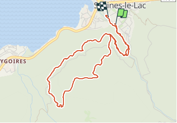

Length
5.8 km

Max alt
1130 m

Uphill gradient
315 m
Km-Effort
10.1 km

Min alt
809 m

Downhill gradient
328 m
Boucle
Yes
Creation date :
2023-09-27 14:13:17.499
Updated on :
2023-09-27 15:59:01.047
1h45
Difficulty : Medium

FREE GPS app for hiking
 SityTrail
IGN / Geographical institutes
SityTrail Plus
The world is yours!
About
Trail Walking of 5.8 km to be discovered at Provence-Alpes-Côte d'Azur, Hautes-Alpes, Savines-le-Lac. This trail is proposed by Maca8284.
Positioning
Country:
France
Region :
Provence-Alpes-Côte d'Azur
Department/Province :
Hautes-Alpes
Municipality :
Savines-le-Lac
Location:
Unknown
Start:(Dec)
Start:(UTM)
293730 ; 4933285 (32T) N.
Comments