


La Seyte

Léger Michel
User
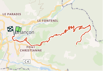

Length
17 km

Max alt
2083 m

Uphill gradient
896 m
Km-Effort
29 km

Min alt
1214 m

Downhill gradient
889 m
Boucle
Yes
Creation date :
2023-09-27 11:17:27.439
Updated on :
2023-09-27 16:43:49.409
5h25
Difficulty : Very difficult

FREE GPS app for hiking
 SityTrail
IGN / Geographical institutes
SityTrail Plus
The world is yours!
About
Trail Walking of 17 km to be discovered at Provence-Alpes-Côte d'Azur, Hautes-Alpes, Briançon. This trail is proposed by Léger Michel.
Positioning
Country:
France
Region :
Provence-Alpes-Côte d'Azur
Department/Province :
Hautes-Alpes
Municipality :
Briançon
Location:
Unknown
Start:(Dec)
Start:(UTM)
313479 ; 4974211 (32T) N.
Comments