


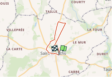
Saint-Branchs - les Boissières Chemin du Rail - 8.3km 35m 1h45 - 2023 09 27

Orcal37
User GUIDE

Length
8.3 km

Max alt
102 m

Uphill gradient
35 m
Km-Effort
8.7 km

Min alt
86 m

Downhill gradient
34 m
Boucle
Yes
Creation date :
2023-09-27 14:27:11.757
Updated on :
2023-09-28 16:59:55.536
1h45
Difficulty : Easy

FREE GPS app for hiking
 SityTrail
IGN / Geographical institutes
SityTrail Plus
The world is yours!
About
Trail Walking of 8.3 km to be discovered at Centre-Loire Valley, Indre-et-Loire, Saint-Branchs. This trail is proposed by Orcal37.
Description
Saint-Branchs - les Boissières - Chemin du Rail - 8.3km 35m 1h45 - 2023 09 27
Photos


Positioning
Country:
France
Region :
Centre-Loire Valley
Department/Province :
Indre-et-Loire
Municipality :
Saint-Branchs
Location:
Unknown
Start:(Dec)
Start:(UTM)
331722 ; 5232618 (31T) N.
Comments