


sortie 1 CAF VTT 2023

psesjs
User
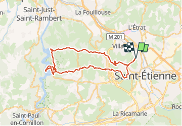

Length
32 km

Max alt
633 m

Uphill gradient
823 m
Km-Effort
43 km

Min alt
419 m

Downhill gradient
823 m
Boucle
Yes
Creation date :
2023-09-28 13:27:59.923
Updated on :
2023-09-28 13:28:06.12
2h59
Difficulty : Difficult

FREE GPS app for hiking
 SityTrail
IGN / Geographical institutes
SityTrail Plus
The world is yours!
About
Trail Mountain bike of 32 km to be discovered at Auvergne-Rhône-Alpes, Loire, Saint-Étienne. This trail is proposed by psesjs.
Positioning
Country:
France
Region :
Auvergne-Rhône-Alpes
Department/Province :
Loire
Municipality :
Saint-Étienne
Location:
Unknown
Start:(Dec)
Start:(UTM)
607483 ; 5034586 (31T) N.
Comments